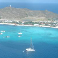
Venezuela Yours... Geography
In geography, there are two ways of dividing a territory. The first one is a physical division, where regions with similar characteristics, from a point of view of topography, vegetation and climate, are grouped together. The second way, the political division, where the territory is divided in states with a common administration (governors, local congress...).
Physical Division
Here again, there are two ways of dividing the country. The easiest one, divides Venezuela in 3 big regions:
- Andes-Coast
- "Llanos" (Prairies)
- Guayana
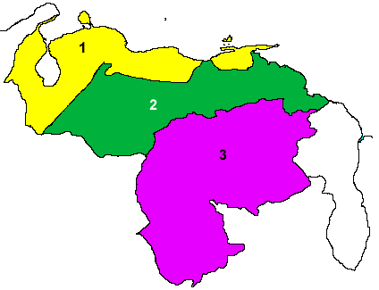
However, it is our opinion, that this way of grouping is putting together places that are very different, for instance Maracaibo and Merida). That is why we like much more the division proposed in the book "Image of Venezuela: An space vision", published by Petroleos de Venezuela and the "Instituto de Ingenieria". This division is based in the study of satellite images.
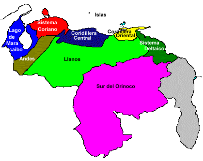
The territory is divided in the following nine regions:
- Cordillera Central (Central chain)
- Cordillera Oriental (East Chain)
- Sistema Coriano (Coro system)
- Lago de Maracaibo (Lake of Maracaibo)
- The Andes
- The Llanos (Prairies)
- Sistema Deltáico (Orinoco delta)
- Sur del Orinoco (South of Orinoco)
- Las Islas (The Islands)
In comparison with the previous division, the Andes-coast region is divided between the Central an east chain of mountains, the Andes, the Coro system and the lake of Maracaibo. The "Llanos" separated from the Orinoco Delta system, and the islands are treated like a different region.
Political Division
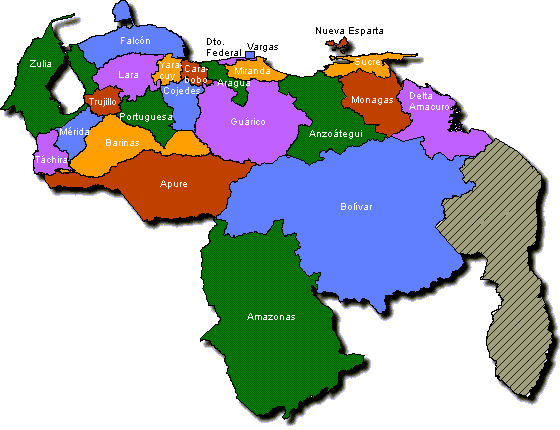
Click here for a more detailed map
States of Venezuela
Federal Entity
Amazonas
Anzoátegui
Apure
Aragua
Barinas
Bolívar
Carabobo
Cojedes
Delta Amacuro
Dist Federal (DF)
Falcón
Guárico
Lara
Mérida
Miranda
Monagas
Nueva Esparta
Portuguesa
Sucre
Táchira
Trujillo
Vargas
Yaracuy
Zulia
TOTAL
Population (thousands)
101
1,115
437
1,428
558
1,240
1,992
248
128
1,975
729
617
1,522
720
2,485
583
359
786
808
998
579
301
498
3,052
23,277
%
0,44%
4,79%
1,88%
6,13%
2,40%
5,33%
8,56%
1,07%
0,55%
9,85%
3,13%
2,65%
6,54%
3,09%
10,68%
2,50%
1,54%
3,38%
3,47%
4,29%
2,49%
Incluido en DF
2,14%
13,11%
Capital
Puerto
Ayacucho
Barcelona
San Fernando
Maracay
Barinas
Ciudad Bolívar
Valencia
San Carlos
Tucupita
Caracas
Coro
San Juan de los Morros
Barquisimeto
Mérida
Los Teques
Maturín
La Asunción
Guanare
Cumaná
San Cristóbal
Trujillo
La Guaira
San Felipe
Maracaibo
Other Cities
Puerto La Cruz
El Tigre
Guasdualito
Turmero,
La Victoria
Barinitas
Ciudad Guayana,
Upata
Puerto Cabello,
Guacara
Tinaquillo
Punto Fijo,
Punta Cardón
Calabozo,
Valle de la Pascua
Carora,
Cabudare
El Vigía,
Ejido
Santa Teresa del Tuy
Caripito,
Punta de Mata
Porlamar
Acarigua,
Villa Bruzual
Carúpano,
Güiria
Rubio,
San Antonio
Valera,
Boconó
Catia la mar,
Macuto,
Naiguatá
Yaritagua,
Chivacoa
Cabimas,
Ciudad Ojeda
Source, El Nacional (13-7-99)
Click here to see the main cities, their heights and distances among them
Bibliography:
- Imagen de Venezuela: Una visión espacial - Pdvsa - Instituto de Ingeniería
- Atlas de Venezuela - Litografía Tecnocolor
Fin Espacio Publicitario